NOSTALGIA: Mystery picture of Portsmouth: do you recognise this scene?

I know many of you have bought my new book Portsmouth In Transition but if you have not and would like a personalised signed copy for a Christmas present I shall be at Waterstones in Commercial Road on Friday from 10.30am until midday and then again on Sunday from 11am until 12.30pm. Hope to meet you there.
Can anyone take a guess where this photograph was taken? I think it might be along Pembroke Road.Can anyone take a guess where this photograph was taken? I think it might be along Pembroke Road.
Can anyone take a guess where this photograph was taken? I think it might be along Pembroke Road.

There’s more from the book here today.

Let’s go straight to the then-and-now pictures where the old photo shows Staunton Street and Church Street in 1962.

We’re looking across wasteland towards the chancel of All Saints’ Church, Landport.

Hide Ad
Hide Ad
Looking west towards the chancel of All Saints Church, Landport. The crossroads is of Church Street and Staunton Street. Picture: Eddie WallaceLooking west towards the chancel of All Saints Church, Landport. The crossroads is of Church Street and Staunton Street. Picture: Eddie Wallace
Looking west towards the chancel of All Saints Church, Landport. The crossroads is of Church Street and Staunton Street. Picture: Eddie Wallace

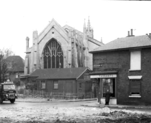
It is an area that has little to say for itself. Mrs Anne Tarrant ran the bakers on the corner of Staunton Street.

Whether the wasteland was caused through demolition or wartime bombing, I don’t know. It is 1962 and 20 years since the Luftwaffe came in force during the Blitz.

In the modern picture the wasteland has been cleared and modern housing and flats now cover the area. Much of the neighbourhood is covered in lawns and trees.

All Saints’ still ministers to local parishioners.

Looking across Church Street to All Saints Church today.Looking across Church Street to All Saints Church today.
Looking across Church Street to All Saints Church today.

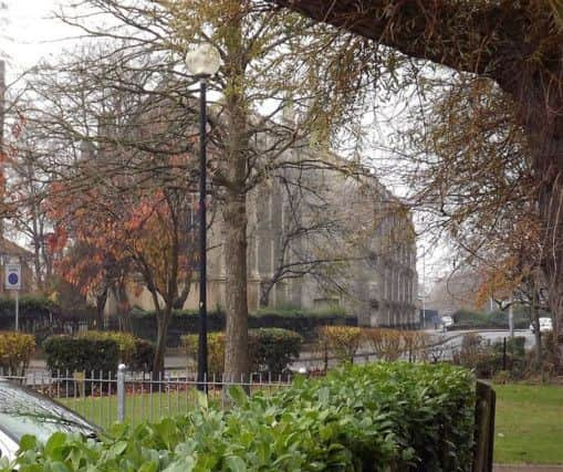
Although surrounded by housing, the greenery makes the landscape so different to what was once there.

Hide Ad
Hide Ad

•Can anyone tell me where the photograph at the top might have been taken? It comes from Barry Cox and he does not know either.

I think it could be in Pembroke Road with part of Victoria Barracks behind the fence.

Anyone who knows please get in touch.

Looking south at Kingston Cross in 1928. Kingston Road has been blocked to traffic for the Fratton Road widening. (Barry Cox collection)Looking south at Kingston Cross in 1928. Kingston Road has been blocked to traffic for the Fratton Road widening. (Barry Cox collection)
Looking south at Kingston Cross in 1928. Kingston Road has been blocked to traffic for the Fratton Road widening. (Barry Cox collection)

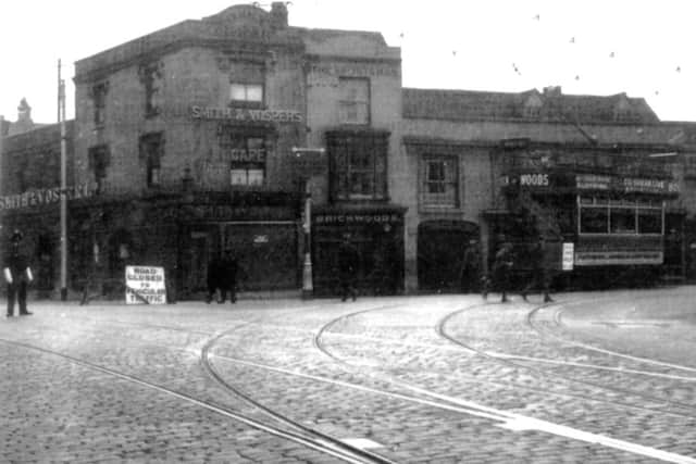
•You will never guess where the final picture is.

It is Kingston Cross in 1928 with the tram turning down Kingston Crescent.

Smith & Vospers dominates the corner.

The constable is making sure no traffic proceeds down Kingston Road as from St Mary’s Road to Fratton Bridge the road was being widened.

Hide Ad
Hide Ad
Looking west towards the chancel of All Saints Church, Landport. The crossroads is of Church Street and Staunton Street. Picture: Eddie WallaceLooking west towards the chancel of All Saints Church, Landport. The crossroads is of Church Street and Staunton Street. Picture: Eddie Wallace
Looking west towards the chancel of All Saints Church, Landport. The crossroads is of Church Street and Staunton Street. Picture: Eddie Wallace

All the buildings on the east side of the road were demolished the road widened and the single tramlines made into double tracks.

The work was finished by July 25, 1929, and the road opened by the lord mayor. Fratton Bridge was also widened.

Related topics: