Online tool allows people to fly virtually over historic Portsmouth and the south coast for the first time
and live on Freeview channel 276
Historic England has released its Aerial Archaeology Mapping Explorer tool which allows anyone to discover the history on our doorstep.
Archaeology enthusiasts have thousands of archaeological sites – some 6,000 years old dating back to The Stone Age – all at their fingertips.
Advertisement
Hide AdAdvertisement
Hide AdPeople can also explore the history of the Second World War along the south coast through the freely available online tool.

Anti invasion defences including gun emplacements, coastal gun batteries, anti-tank blocks and barbed wire can all be seen virtually, with the wartime defences at Newhaven, East Sussex, being one of the more detailed examples.
Historic England chief executive Duncan Wilson said: ‘This new aerial archaeology mapping tool lets people fly virtually over England and drink in its many layers of history.
‘It will allow everyone to explore the hidden heritage of their local places and what makes them special.’
Advertisement
Hide AdAdvertisement
Hide Ad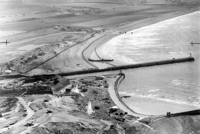

The tool displays thousands of archaeological sites captured by aerial photographs over the past 30 years.
Over half a million photos were analysed to piece together the maps which cover more than half of England, which Historic England say are like ‘a huge archaeological jigsaw puzzle.’
Remains such as Roman settlements and Iron Age hill forts can be seen individually or as part of sweeping historical landscapes.
Each point of interest is dated, described and has links to more in-depth archive information.
Advertisement
Hide AdAdvertisement
Hide AdStyles of maps can be changed and photographs of some remains can be seen by anyone.
Airborne laser scanning technology, also known as lidar data, created 3D images of the landscape and showed where these archaeological remains are.
Mr Wilson added that he hopes the new software will pique historical curiosity for all sorts of reasons.
He said: ‘We hope it will give people a springboard to further investigation, whether for research purposes or simply to satisfy curiosity about what archaeological features they may have noticed around their local area.’
A message from the Editor, Mark Waldron
Advertisement
Hide AdAdvertisement
Hide AdWe’ve slashed the cost of digital subscriptions to our website by 50 per cent for a limited time.
You can now subscribe here for unlimited access to our online coverage, including Pompey, for less than 13p a day.
Comment Guidelines
National World encourages reader discussion on our stories. User feedback, insights and back-and-forth exchanges add a rich layer of context to reporting. Please review our Community Guidelines before commenting.