The long fight for a right of way at the Camber in Old Portsmouth – why residents will not let up


At that time the concept of Brexit had not yet entered into the public consciousness, Barack Obama was still in office under his second term as president of the USA and Portsmouth City Council was led by a Conservative administration.
But for Old Portsmouth residents, particularly those concerned with access rights to the Camber, they are still locked in a battle with the council that began five years ago.
Advertisement
Hide AdAdvertisement
Hide AdSince the construction of the £12m Ben Ainslie Racing (BAR) headquarters in the Camber, which started in 2014, there has been conflict over the legal standing of the public's right to walk around the 575 metre perimeter of the dock.
Residents immediately raised fears over the BAR development as they claimed they had always been able to walk around the dock unobstructed and were worried this was about to change.
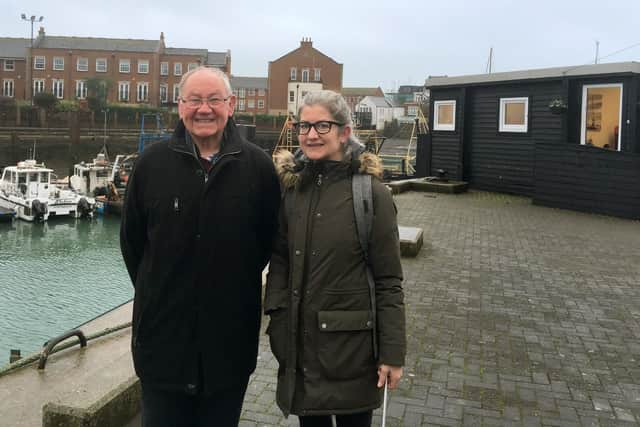
Ken Bailey, from the Camber Action Group, said: 'I have lived in Old Portsmouth my whole life. I was born here and my family have lived in this area for the past 200 years. When the Ben Ainslie building was proposed I didn't like it but particularly I didn't like the fact they were taking away access to the quays. I played on them as a child.'
Fellow campaigner, Anna Koor, added: 'I live around here and used to walk around the Camber with my husband most evenings.
Advertisement
Hide AdAdvertisement
Hide Ad'When we got wind of this application the alarm bells started going off, thinking that they were going to block access to the water's edge.'
They were told by the council that the route was not a public right of way as it was not included on the definitive map and statement - a document that records all rights of way in the city and was since revealed to have been lost several years earlier.
In November 2014 the group asked the council to change the map to include the right of way or else they would put in a formal application to get it changed - known as a modification order.
By law the council had 12 months to investigate this claim. Exactly a year to the day the council rejected this request. The group say this was due to the fact they had applied for the path to be a byway open to all traffic, which was the wrong classification.
Advertisement
Hide AdAdvertisement
Hide AdCampaigners pooled money for legal advise and put together a case for the route to be recognised as either a restricted byway or a footpath. Again, this was rejected in July 2017 as the council claimed 'statutory incompatability' - meaning access was not suitable due to the site's function as a port.
However, an appeal to the Department for Environment, Food and Rural Affairs (Defra) ruled that a restricted byway, for use of walkers, riders and cyclists, should be added to the definitive map as the Camber route.
Again the council had 12 months to make these changes.
To meet this a legal order will be made by February 21 this year to start a public inquiry to consider if the council's definitive map and statement of rights of way should be altered to include the restricted byway.
In the meantime the council has issued an access policy on the route, which although is not legally binding, does show that there is access to the dock. A public consultation was held on the policy, which closed on January 20.
Advertisement
Hide AdAdvertisement
Hide AdMichael Lawther, the council's solicitor, said: 'The access policy doesn’t affect the public inquiry and debate around the future definition of access to the camber; it is intended to reassure residents of the unrestricted access to the area.'
All campaigners can do now is wait.
Ken said: 'The access policy actually adds more restrictions than are there today. It says it will close it on Christmas Day every year, and it says no unaccompanied 18-year-olds will be allowed in the area.
'This whole scheme took away the public's rights and when the next Ben Ainslie comes along it will happen again. We will lose it unless we protect it. We are only interested in protecting the rights we have for the future.’
Anna added: 'We just want to make sure we can still get access to the waterfront as we always have done.'
Advertisement
Hide AdAdvertisement
Hide AdThe route around the Camber is currently accessible, despite being reduced width-wise by the BAR building, but defining it as a restricted byway would protect public accessibility by law.
The mystery of the lost map
SORTING out the classification of the Camber route was hindered further when it was revealed the council had lost its definitive map and statement somewhere around 2011.
The map, which is a physical item, documents all rights of way in the city. However, its loss meant that there was no record of how the Camber had been previously defined.
Camber Action Group member Ken Bailey said this was frustrating as the map was used as a reference to dismiss their original case. 'In 2014 the council said this is not a formal right of way as it is not on the definitive map,' he said.
Advertisement
Hide AdAdvertisement
Hide Ad'But how could they say that when we know now that they didn't have a copy of it?'
Pam Turton, the council’s assistant director of transport, said: ‘We have not added a right of way since 2010, and the last record of the council holding a paper copy of the definitive map and statement was in 2011, when a digital copy was made.
‘The digital version is based on information contained in the physical copy, which was correct at the time. Since then we have always referred to the digital copy, so it is not clear how or when the sealed copy of the definitive map and statement was lost.'
Landowners and members of the public were asked to engage in a consultation to help create a new definitive map and statement of Portsmouth, which closed on January 27.
'It is vital that Portsmouth City Council finally listens'
Advertisement
Hide AdAdvertisement
Hide AdA CITY MP has criticised the drawn-out process of determining the access of the Camber route.
Portsmouth South MP and Councillor Stephen Morgan said: 'This process has dragged on and on, and I share residents' frustration. A consultation by the council has been undertaken on a proposed access policy and I hope everyone has had the chance to have their say.
'The Camber is a real asset to our city’s seafront and local residents have ran an important campaign to improve access at the historic location in this special part of our city.
'I have been undertaking a variety of actions to support campaigners at the Camber. Meeting with concerned residents, taking a walkabout of the area, submitting parliamentary questions and arranging a meeting to discuss the issue between the city council and Friends of Old Portsmouth.
'It is now vital that Portsmouth City Council finally listens to residents concerns and prioritises action.'