Ancient lane from Bedhampton to Langstone Harbour | Nostalgia


The first was the reference to the Portsmouth-Arundel canal. The second to the evidence that still survives of a once important route.
Mr Tate says: ‘I am one of a group of residents who have come together to safeguard the heritage assets of Bedhampton.
Advertisement
Hide AdAdvertisement
Hide Ad‘As part of our efforts we have come to recognise the significance of Narrow Marsh Lane in the history of Bedhampton and Havant. The lane ran from Lower Road across the coastal salt marshes and out into Langstone Harbour at Broadmarsh.
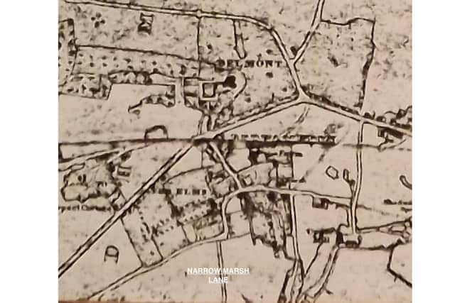
‘This southern section within the harbour is still visible and runs out towards the deep water channel created by the Hermitage Stream to a place identified on old maps as 'Landing'.
‘The other remaining northern section runs from the railway line to Lower Road. Unfortunately the middle section was lost to landfill associated with the construction of the A27 by-pass in the 1970s, now forming part of the Harts Farm Way employment area.’
Mr Tate adds: ‘When the railway was built two bridges were constructed in close proximity. A sweeping reverse-curved arched bridge connecting Mill Lane in a gradient that allowed hand carts to pass between the Mills, Granary and Biscuit Factory and a smaller single arched bridge skewed to maintain the directness of Narrow Marsh Lane. Both these lanes will have connected to Landing. The provision of these bridges must have reflected their status and historic usage.
Advertisement
Hide AdAdvertisement
Hide Ad‘Records show the case for the Mill Lane bridge was won in parliament and contemporary land ownerships either side of Narrow Marsh Lane included entrepreneurs known to be involved in the canal initiative and perhaps concerned about the impact of the railway on their project.

‘After the A27 works the remaining northern section was used as a public thoroughfare connecting south of the railway in an easterly direction with Mill Lane until the landowner blocked this link. It is hoped this will be made a public right of way in the future.’
Mr Tate concludes: ‘The lane may have ancient pre-settlement origins. It is at the eastern end of Portsdown Hill, which would have presented an obstacle to movement between the rich but marshy coastal plain and the Hampshire hinterland, especially the winter shelter of the Forest of Bere. At Bedhampton, the east/west summer movements along the coast met the north/south winter movement connecting routes between Langstone and the forest.’
Comment Guidelines
National World encourages reader discussion on our stories. User feedback, insights and back-and-forth exchanges add a rich layer of context to reporting. Please review our Community Guidelines before commenting.