Royal Navy sailors on Portsmouth-based HMS Spey find Henderson Island in the Pitcairns in the Pacific has been 'in the wrong place' for 85 years
and live on Freeview channel 276
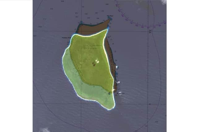
Henderson Island in the South Pacific is a mile south of the position marked on charts used by mariners the world over since 1937.
On the eve of British Science Week, Portsmouth-based patrol ship HMS Spey confirmed the error as part of efforts to check and update charts of waters around British Overseas Territories scattered around the globe.
Advertisement
Hide AdAdvertisement
Hide AdHenderson is about the size of Oxford, but nobody lives on it. It is one of four islands in the remote Pitcairn chain.
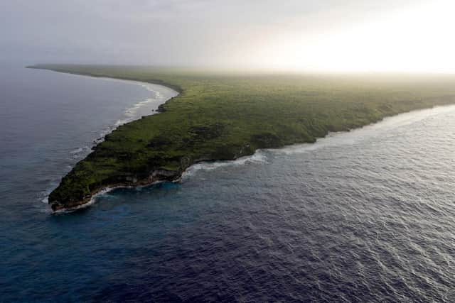


Chile is 3,600 miles to the east and New Zealand 3,200 miles to the southwest.
The Royal Navy has been using navigational charts supplied by the UK Hydrographic Office, using the latest technology of the day, for more than 225 years.
Over the past 15 years, the majority of the Fleet has used digital charts. Key areas and seas regularly used are well covered by the electronic system which not only ensures pinpoint navigational accuracy, but allows sailors to ‘interrogate’ key features such as landmarks, buoys and depths, as well as turning specific features on/off as required.
Advertisement
Hide AdAdvertisement
Hide AdThe Pitcairn chain has only had some satellite-based data collection, which had already highlighted the inaccurate positioning on historical charts, so Spey offered to assist with data gathering.
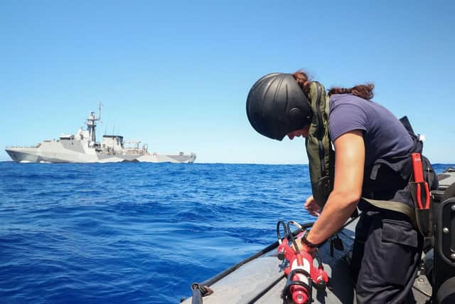
She is not a dedicated survey vessel, but navigator Lieutenant Michael Royle used radar imagery gathered by Spey’s sensors and GPS positioning, overlaying the details on the existing charts of the Pitcairn chain.
‘In theory, the image returned by the radar should sit exactly over the charted feature – in this case, Henderson Island,’ Lieutenant Royle said.
‘I found that wasn’t the case – the radar overlay was a mile away from the island, which means that the island was plotted in the incorrect position when the chart was first produced. The notes on the chart say that it was produced in 1937 from aerial photography, which implies that the aircraft which took the photos was slightly off in its navigational calculations.’
Advertisement
Hide AdAdvertisement
Hide AdThe work by Spey is part of a wider government programme to update maritime charts of waters around the UK’s Overseas Territories and improve navigation using sonar, airborne laser techniques and satellites to better understand, manage and protect the marine estates of these territories.
Henderson Island was last visited by the Royal Navy in late 2018 when HMS Montrose conducted an environmental survey to study the impact of plastics in the oceans.
Pacific currents dump masses of debris on the shoreline of the British Overseas Territory – an estimated 270 objects every day, with as many as 40 million items of plastic and rubbish scarring Henderson’s beaches, earning it the title ‘most polluted island in the world’.
As well as some outdated charts, knowledge about the waters around the entire Pitcairn chain is limited, so at all four islands – Ducie and Oeno and complete the quartet – HMS Spey launched her sea boat and crew filled tanks with water.
‘Scientists in the UK have really scant data about the ocean in this region – its salinity, temperature, water pressure and the like,’ Lt Royle added. ‘They are keen to understand climate change in the area.’
The ship also conducted patrols in the waters around the islands to deter and defend against illegal fishing, in partnership with the UK’s satellite monitoring programme run by the Marine Management Organisation.
Portsmouth-based Spey is on a five-year mission to the Indo-Pacific region with her sister HMS Tamar, a mission which has already seen her help the people of Tonga in the wake of the recent tsunami.