Storm Ciaran: Major incident declared on south coast of Hampshire amid high winds and heavy rain
and live on Freeview channel 276
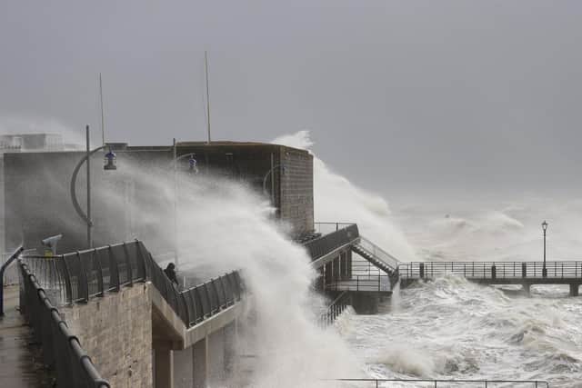
Most of the 54 flood warnings issued by the Environment Agency where flooding is expected are along the south coast, where a major incident has been declared in Hampshire and the Isle of Wight. A further 134 alerts are in place for possible flooding.
READ NOW: Schools closed
Ben Lukey, flood duty manager at the Environment Agency, said: “Large waves and onshore gales brought by Storm Ciaran could see significant flooding along parts of the south coast and along parts of the Yorkshire and Northeast coasts on Thursday.”

Advertisement
Hide AdAdvertisement
Hide AdThe major incident was declared by the Hampshire and Isle of Wight Local Resilience Forum, with the local fire service warning there was a “potential risk to life” as well as a risk of damage to buildings, falling trees, and flooding.
Across the south coast, an amber warning runs from 6am to 5pm on Thursday with winds expected to reach 70mph to 80mph, with the potential for 85mph and large waves.
A further amber warning is in place until 11am in Cornwall and Devon, with the Met Office predicting Storm Ciaran will bring winds of 75mph to 85mph, with 65mph to 75mph gusts inland.
A red wind warning, the highest level, was issued by Jersey Met into Thursday with people warned to avoid outside activity due to predicted gusts of almost 100mph. The French coast saw winds of up to 110mph in western Brittany overnight.
Advertisement
Hide AdAdvertisement
Hide AdAll flights from Jersey, Guernsey and Alderney airports on Thursday have been cancelled.
Commuters in southern England were urged to work from home by Southern Rail, with Southeastern “strongly advising” passengers not to travel on routes in and out of London before 9am on Thursday as they assess any fallen trees and debris on the line.
Other operators were warning of delays and cancellations.
A spokesperson on behalf of train operators said: “Our colleagues will be working extremely hard over the coming days to keep passengers on the move but also to keep them safe during this bad weather.
“We will be working closely with Network Rail to understand the impact on the rail network, and we are encouraging passengers to check their journey before travelling.”
Advertisement
Hide AdAdvertisement
Hide AdMet Office deputy chief meteorologist Brent Walker said: “Very strong winds are expected along southern coastal areas of England in particular, where gusts of 70 to 80mph are possible, perhaps exceeding 85 mph in a few exposed locations. Further inland, gusts could reach up to 50 or 60mph.
“As well as strong winds, there will be heavy rain across many parts of the UK.
The Royal National Lifeboat Institution (RNLI) urged people watching the conditions to stay away from the coast.
RNLI water safety manager Ross Macleod said: ‘This rough weather could make visiting our coasts around southern England and Wales treacherous and bring very dangerous sea conditions.
Advertisement
Hide AdAdvertisement
Hide Ad“While people may want to experience extreme weather around the coast, we would strongly advise against doing so. It is not worth risking your life, so we urge people to respect the water and watch from a safe distance.”
Northern Ireland has already seen flooding, where a yellow rain warning from the Met Office was in place until 9am on Wednesday.
A similar notice was issued for southern parts of England and Wales from 6pm on Wednesday until the end of Thursday.
A yellow warning for rain is also in place from 6am on Thursday to 6am on Friday for north-east England and Scotland, stretching up to Inverness.