Storm Eunice: What is the 'sting jet' phenomenon warned by the Met Office, how do they form, how do they get their name, how are they forecasted, and will the storm wreaking Portsmouth and Hampshire produce one?
and live on Freeview channel 276
This abnormality is known as a ‘sting jet’, and the storm may produce one.
Storm Eunice has already had a devastating effect on Portsmouth and Hampshire.
Advertisement
Hide AdAdvertisement
Hide AdFerries have been filmed battling against ferocious seas, Hayling Island has been cut off due to the closure of Langstone Bridge, and a family in Waterlooville are trapped in their home due to a fallen tree – blown over by strong winds.
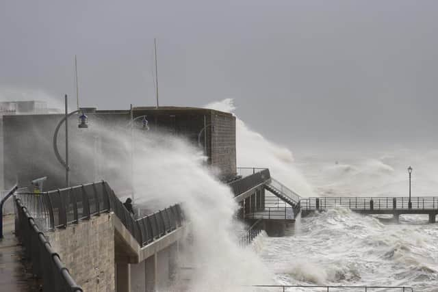


Southsea seafront has also been battered by extreme waves, caused by the storm – with a red weather warning in place over Portsmouth.
Due to the conditions caused by Storm Eunice, the Met Office explained a sting jet could form.
What is a sting jet?
The weather forecaster’s definition of a sting jet is a small area of very intense winds – often reaching more than 100mph.
Advertisement
Hide AdAdvertisement
Hide AdIt is a core of strong winds which sometimes forms in rapidly deepening areas of low pressure, and often extends towards the ground.
Relative to the size of a storm, the sting jet is narrow, often 30 miles across, and usually lasts between three to four hours.
The Met Office said a sting jet can cause ‘significant damage and risk to life.’
One of the most prominent examples of a sting jet, according to the Met Office, is the Great Storm of 1987 – which took 18 lives.
Advertisement
Hide AdAdvertisement
Hide AdThe forecaster said wind speeds reached 115mph and an estimated 15 million trees were blown down by gusts.
How do they get their name?
The weather formation gets its name from its resemblance to the sting in a scorpion’s tail.
On satellite images, the end of the so-called ‘cold conveyor’ is marked by a hook-shaped cloud with a point at the end, according to the Met Office.
How do they form?
The forecaster said weather fronts separate areas of warm and cold air, and their interaction creates and develops wet and windy weather.
Advertisement
Hide AdAdvertisement
Hide AdThere are more focused streams of warm and cold air close to the weather fronts.
These are known as conveyor belts, with the warm conveyor rising and the cold conveyor falling.
The Met Office said these ‘wrap around the area of low pressure and help develop it by feeding warm air and moisture into the system’.
They added: ‘The cold conveyor brings its cold air from higher in the atmosphere and from being in a cold air mass. Sometimes it has help from rain and snow as they fall into it and evaporate.
Advertisement
Hide AdAdvertisement
Hide Ad‘This change from liquid to gas requires heat, which is removed from the conveyor, cooling it further. Now we have even colder air falling along the conveyor, speeding up as it does so, like a rollercoaster taking the first drop.
‘As this wind reaches the surface it can often produce much stronger gusts than would otherwise be made by the storm. However, the cold conveyor catches up with itself after a few hours and consumes the sting jet, keeping the length of time and area of potential damage quite small.’
How are sting jets forecast?
Information from the Met Office website said due to their relatively small size, and the way each individual low-pressure system develops, sting jets are hard to forecast.
Although, they can be seen on weather models, which can highlight cores of very strong winds.
Advertisement
Hide AdAdvertisement
Hide AdSting jets can also be spotted on satellite images, with some showing the amount of water vapour in dark and light shades.
The darker the shade, the lower amount of water vapour.
The Met Office said on its website: ‘We know that clouds are made when water vapour condenses into water droplets, but around the sting jet there are often dark fingers of air stretching out, telling us that the rollercoaster of wind is also very dry.
‘A small core of fast-moving, cold, dense, dry air.’
Will Storm Eunice produce a sting jet?
An expert highlighted that Storm Eunice may cause a sting jet, though it is not confirmed as of yet.
Dr Peter Inness, meteorologist at the University of Reading, said: ‘Eunice looks like it may be able to produce a ‘sting jet’, a narrow, focused region of extremely strong winds embedded within the larger area of strong winds and lasting just a few hours.’
Advertisement
Hide AdAdvertisement
Hide AdYou can follow live updates of how Storm Eunice is affecting Portsmouth here.
A message from the Editor, Mark Waldron
Subscribe here for unlimited access to all our coverage, including Pompey, for just 26p a day.
Comment Guidelines
National World encourages reader discussion on our stories. User feedback, insights and back-and-forth exchanges add a rich layer of context to reporting. Please review our Community Guidelines before commenting.